|
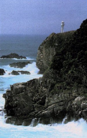
On August 1, 1954 (Showa 29), the neighboring four towns of Shimizu, Shimonokae, Misaki, and Shimokawaguchi were united to create Tosashimizu City. It has an area of 266.67 km, a population of 21,182 (1990 census) and has developed primary industries with agriculture, forestry and fishery taking a leading part and as a tourism town filled with beautiful nature. Tosashimizu is situated in the south-west area of Shikoku and faces the Pacific Ocean. It's located 150 km south-west of Kochi City (the prefectural capital) by way of National road 56 and 321. Its longitude is 132 degrees 57 minutes East and the latitude is 32 degrees 46 minutes North. It is 25 km from the east side to the west side of Tosashimizu and 24 km from north to south. It is bounded by Nakamura City, Mihara Village, Sukumo City and Otsuki Town in the north and west and has steep low mountains and flat low lands. The nature of the soil was formed mostly with sandstone and shale. The south and east areas of Tosashimizu face the Pacific Ocean and its warm Black Current and has one of the best fishing grounds in Japan. The climate is subtropical and the annual precipitation is about 2,313 mm. The average temperature throughout the year is 17.8C, which is one of the warmest in Japan. Eighty-five percent of Tosashimizu consists of mountains and forests and the Ashizuri Cape area which is the center of the Ashizuri-UwaSea national Park and has an abundance of natural subtropical forests. The deep blue ocean is rich with the warm Black Current, blue sky and towering precipices. There is also a sawtooth coastline and the first underwater observatory in Tatsukushi. Ashizuri and Tatsukushi are known for their scenic beauty without pollution. --Taken from the book, "May I Help You? : Welcome to Tosashimizu City" published by the Tosashimizu Junior Chamber, 1991. Visit the tourism page for Kochi Prefecture. There you'll find a link to Tosashimizu (currently only in Japanese).
Back to the John Manjiro Page. Carolyn Longworth e-mail to clongworth@sailsinc.org
|